Coastal erosion and flooding from climate change has made it necessary for the municipality of East Hants to propose restriction changes to the zoning of some of the properties which are close to the ocean waters of Cobequid Bay. A public hearing is planned for July 27th, 2023 at 7PM at the Lloyd E. Matheson Center, in Elmsdale.
The official link to their site is: easthants.ca/community-plan-update
Email contact is: planning@easthants.ca
You can use their site to see the effect on your property by civic address or by your property PID number.
My summarization
The following are my summarization of the information there, plus issues and links to other related resources.
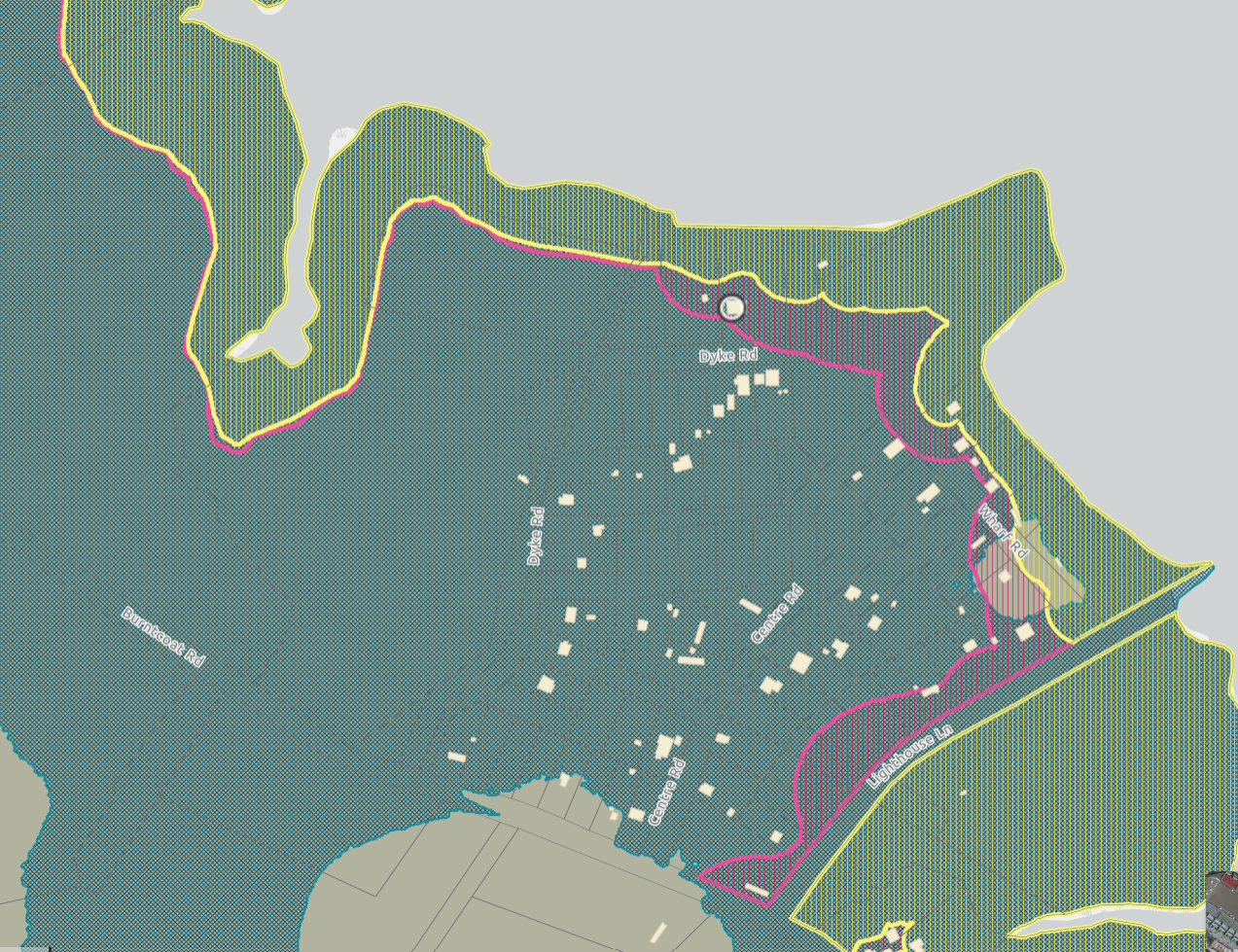
There are three zones identified, each which relates to water level predictions into the future.
- The teal coloured FF Fundy Floodplain zone is the major one, which affects most property owners in the Dyke Road to Lighthouse Lane area. New structures in this zone need to be 10 Meters above the water level (refer to document CGVD2013)
- The yellow coloured FE2050 Fundy Erosion zone, shows the land that is likely to be gone by 2050 (27 years from now). It would not allow any new structures to be built.
- The pink coloured FE2100 Fundy Erosion, shows the land likely to be gone by 2100 (77 years from now). New structures only permitted with a site plan, and need to be removable
More info about Fundy Erosion: Fundy-Erosion-Zone.pdf (easthants.ca)
More information about Fundy Floodplain: Fundy-Floodplain-Zone.pdf (easthants.ca)
Information required in a “Coastal Erosion Study” required to obtain exemption: https://www.easthants.ca/wp-content/uploads/2023/03/Part-11-Appendix-G-Coastal-Erosion-Study.pdf
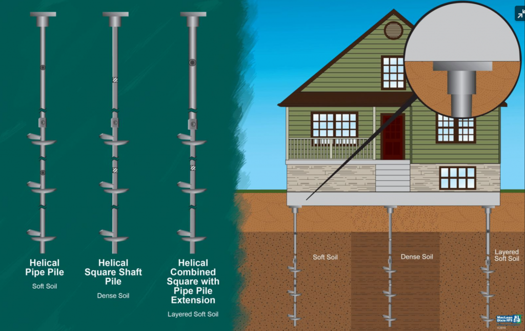
Construction in the pink zone can be placed on Helical Piles, which have spiral plates on a post, or skids.
In The teal coloured FF Fundy Floodplain zone
As per article: Part-10-Environmental-Zones.pdf (easthants.ca)
| 10.10. Fundy Flood Risk (FF) Overlay Zone | |
| Special consideration for those who have installed Armor Rock protection on their shoreline 10.11.3. Coastal Erosion Study If a coastal bank has been stabilized, a main permanent structure may be constructed in accordance with the underlying zone and subject to the approval of a site plan. The Development Officer shall approve a site plan where the following matters have been addressed: a) A Coastal Erosion Study conforming to the format in Appendix E has been submitted which has been prepared by a qualified professional. The study shall demonstrate that the proposed new building is located outside the area which is projected to be lost to coastal erosion by 2100. b) Site design and layout shall locate the new main building as far from the edge of the existing coastline as Page 10-14 PART 10 – ENVIRONMENTAL ZONES possible. c) An application for site plan approval shall be in the format specified in Appendix C and shall be accompanied by a sketch in sufficient detail to address all of the matters identified above. The refusal or approval of a site plan is appealable to Council in the same manner as an appeal for a variance |
Conclusion
We will definitely be attending the Public Hearing. Please feel free to reply (anonymously if you want) to share your thoughts and concerns.
My unresolved concern is to determine what the height of the grass at the coastal edge of my property is considered to be, as per the CVGD2013 document.
As a land owner, who has spent time and money protecting the shoreline of our property, we realize that it is important to plan appropriately for the continual coastal flooding challenges.
We mainly want to ensure the continued enjoyment of our coastal property, without too much complication.
Rob and Cathy
Please SUBSCRIBE to our NOTIFICATIONS
If you would like to be notified of more articles like this, please LIKE our Facebook page, which will then include us in your Facebook feed. Use this LINK to take you to our page, then click the LIKE button shown below. Or Like our twitter feed.